

Hiking Kuala Lumpur: A Complete Guide to the Best Trails and Attractions

Oleh Trip.com
7 Mac 2024
Do you love hiking and nature? If so, you should definitely visit Kuala Lumpur, the capital city of Malaysia. Kuala Lumpur, or KL for short, is not only a bustling metropolis with modern skyscrapers, shopping malls, and cultural landmarks, but also a great destination for hikers and nature lovers. There are many hiking trails available in and around KL for different levels of difficulty and duration, ranging from easy and scenic walks in urban parks to challenging and rewarding climbs in rainforest reserves.
Hiking Kuala Lumpur is a wonderful activity for anyone who wants to enjoy the natural beauty, exercise, and adventure of KL. In this article, you will learn everything you need to know about hiking in Kuala Lumpur, including how to prepare for it, how to choose a hiking trail, and what to expect on each trail. You will also discover some of the best attractions and facilities in or near the hiking trails that you can enjoy after your hike. Whether you are looking for a relaxing getaway, a fun adventure, or a cultural experience, hiking Kuala Lumpur has something for everyone.
How to Prepare for Hiking in Kuala Lumpur
Before you embark on your hiking adventure in Kuala Lumpur, there are some factors to consider when preparing for it. These factors include:
- Weather: Kuala Lumpur has a tropical climate with an average temperature of 28°C and a high humidity of 80%. It also has a high rainfall of about 2500 mm per year, with most of it falling between October and March. The best time to hike in Kuala Lumpur is between June and August, when the weather is relatively dry and sunny. However, you should always check the weather forecast before you go and be prepared for sudden showers or thunderstorms. You should wear light and breathable clothing, a hat or a cap, sunglasses, and sunscreen. You should also bring a raincoat or a poncho, an umbrella, and extra clothes in case you get wet.
- Transportation: There are different options to get to the hiking trails from the city center or other parts of Kuala Lumpur, depending on your budget, time, and convenience. Some of the options are:
- By public transport: You can take a train (LRT, MRT, KTM), a bus (RapidKL), or a taxi (metered or Grab) to get to the nearest station or stop to the hiking trail. You can use apps such as Moovit or Google Maps to plan your route and find the best option. You can also use a Touch 'n Go card or a RapidKL Tourist Pass to pay for your fares.
- By car: You can drive your own car or rent one to get to the hiking trail. You can use apps such as Waze or Google Maps to navigate your way and find the best route. You should also check the traffic conditions before you go and avoid peak hours if possible. You should also look for parking options near the hiking trail and be prepared to pay for parking fees if applicable.
- Safety: Hiking in Kuala Lumpur can be fun and exciting, but also potentially hazardous and risky. You should be aware of some of the potential hazards and risks of hiking in Kuala Lumpur such as heatstroke, dehydration, insects, animals, etc. You should also take some precautions and measures to prevent and deal with them. Some of them are:
-- Drink plenty of water before, during, and after your hike to stay hydrated and avoid heatstroke. You should bring at least 2 liters of water per person per hike.
-- Apply insect repellent on your skin and clothes to avoid mosquito bites and other insect stings. You should also wear long sleeves and pants to cover your skin.
-- Avoid touching or feeding any animals that you encounter on your hike such as monkeys, snakes, lizards, etc. They may be aggressive or carry diseases that can harm you.
-- Stay on the marked trails and do not wander off into the jungle or unknown areas. You may get lost or encounter dangerous situations that can put you in danger.
-- Hike with a group or a partner and do not hike alone. You may need help or assistance in case of an emergency or an accident.
-- Bring a first aid kit with some basic supplies such as bandages, antiseptic wipes, painkillers, etc. You may need them in case of minor injuries or ailments.
-- Bring a phone with enough battery and signal to contact someone in case of an emergency or an accident. You should also inform someone about your hiking plan and location before you go.
-- Here are some emergency contacts that you may need in case of an emergency or an accident:
--- Police: 999
--- Fire: 994
--- Ambulance: 999
--- FRIM Emergency: 03-6279 7575
--- Bukit Broga Emergency: 03-8761 1188
Here is a checklist t that summarizes what to prepare for hiking in Kuala Lumpur:
1. Check the Weather:
- Monitor the weather forecast before your hike.
- Be prepared for sudden showers or thunderstorms.
- Choose the best time to hike between June and August for drier weather.
2. Clothing and Accessories:
- Wear light and breathable clothing suitable for tropical climates.
- Bring a hat or a cap to protect yourself from the sun.
- Wear sunglasses to shield your eyes from glare.
- Apply sunscreen to protect your skin from harmful UV rays.
- Carry a raincoat or a poncho in case of rain.
- Pack extra clothes in case you get wet.
3. Transportation:
- Decide on the mode of transportation based on your budget and convenience.
- Public Transport:
- Check train (LRT, MRT, KTM) and bus (RapidKL) schedules for routes to the trail.
- Use apps like Moovit or Google Maps to plan your route.
- Consider using a Touch 'n Go card or a RapidKL Tourist Pass for fare payment.
- Private Vehicle:
- Check traffic conditions and choose the best route using apps like Waze or Google Maps.
- Look for parking options near the hiking trail.
4. Safety Precautions:
- Stay hydrated by drinking plenty of water before, during, and after your hike.
- Bring at least 2 liters of water per person per hike.
- Apply insect repellent on your skin and wear long sleeves and pants to avoid insect bites.
- Avoid touching or feeding any animals you encounter on the trail.
- Stay on marked trails and avoid venturing into unfamiliar areas.
- Hike with a group or a partner and inform someone about your hiking plan and location.
- Carry a fully charged phone with a signal for emergencies.
- Pack a first aid kit with essentials like bandages, antiseptic wipes, and painkillers.
- Save emergency contact numbers:
- Police: 999
- Fire: 994
- Ambulance: 999
- FRIM Emergency: 03-6279 7575
- Bukit Broga Emergency: 03-8761 1188
Remember, thorough preparation ensures a safe and enjoyable hiking experience. Stay aware of your surroundings and have a great time exploring the beautiful trails in Kuala Lumpur!
The Best Hiking Trails in Kuala Lumpur
In this section, we will describe each hiking trail in detail, using subheadings for each trail name. We will mention the difficulty level, distance, duration, elevation gain, terrain, scenery, attractions, accessibility, safety, and tips for each trail.
Bukit Broga
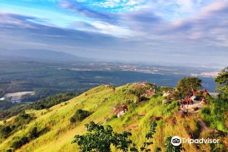
Bukit Broga, or Broga Hill, is an easy and scenic trail that offers panoramic views of the sunrise and the surrounding landscape. It is located in Semenyih, about 50 km from Kuala Lumpur. It is suitable for beginners or those who want a short and simple hike.
- Difficulty level: Easy
- Distance: 3.25 km
- Duration: 1-2 hours
- Elevation gain: 200 m
- Terrain: Paved road with stairs; grassy hill with rocks
- Scenery: Sunrise view and landscape view
- Attractions: The Habitat, Semenyih Dam, etc.
- Accessibility: Easy to access from the parking area near the trailhead
- Safety: Well-marked and well-maintained; watch out for monkeys that may snatch your food or belongings
- Tips: Bring a jacket or sweater as it can get cold at the top; go early to catch the sunrise and avoid the crowd
FRIM Forest Skywalk
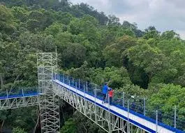
FRIM Forest Skywalk is a moderate and adventurous trail that leads to a canopy walkway above the rainforest. It is located in Kepong, about 16 km from Kuala Lumpur. It is suitable for intermediate hikers or those who want a longer and more adventurous hike.
- Difficulty level: Moderate
- Distance: 4 km
- Duration: 2-3 hours
- Elevation gain: 215 m
- Terrain: Dirt path with rocks and roots; some paved sections; canopy walkway with metal stairs and bridges
- Scenery: Rainforest view and wildlife sightings
- Attractions: The Botanical Garden, The Waterfall, etc.
- Accessibility: Easy to access from the One Stop Centre near the trailhead; need to pay an entrance fee of RM5 per person and a canopy walk fee of RM10 per person
- Safety: Somewhat marked and maintained; some sections are steep and slippery; need to wear a helmet and a harness for the canopy walkway; need to follow the instructions of the staff and guides
- Tips: Bring enough water and snacks as there are no shops or facilities along the way; wear sturdy shoes and gloves as there are some ropes to assist you in climbing; book your canopy walk tickets online or early as there are limited entries per day
Gunung Nuang
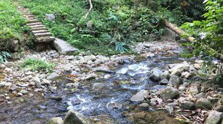
Gunung Nuang is a challenging and rewarding trail that climbs to the highest peak in Selangor. It is located in Hulu Langat, about 33 km from Kuala Lumpur. It is suitable for advanced hikers or those who want a grueling and exhausting hike.
- Difficulty level: Challenging
- Distance: 19.2 km
- Duration: 8-12 hours
- Elevation gain: 1278 m
- Terrain: Dirt path with rocks and roots; some river crossings; some steep sections
- Scenery: Rainforest view and waterfall view
- Attractions: The Lolo Campsite, The Summit Campsite, etc.
- Accessibility: Easy to access from the parking area near the trailhead
- Safety: Somewhat marked and maintained; some sections are very steep and slippery; need to cross a stream at one point; need to register at the checkpoint and pay a fee of RM1 per person
- Tips: Bring enough water and snacks as there are no shops or facilities along the way; wear sturdy shoes and waterproof clothing as it can get wet and muddy; start early and finish before dark as it is a long and tiring hike
Taman Tugu
Taman Tugu is an easy and relaxing trail that loops around an urban park with various flora and fauna. It is located in the city center, near the Tugu Monument. It is suitable for beginners or those who want a short and simple hike.
- Difficulty level: Easy
- Distance: 4 km
- Duration: 1-2 hours
- Elevation gain: 50 m
- Terrain: Paved path with some dirt sections
- Scenery: Park view and city view
- Attractions: The Tugu Monument, The Tugu Nursery, etc.
- Accessibility: Easy to access from the parking area near the trailhead; free shuttle bus service available from KL Sentral or Masjid Negara on weekends and public holidays
- Safety: Well-marked and well-maintained; security guards and CCTV cameras available
- Tips: Bring a picnic basket and enjoy a meal at one of the designated picnic areas; visit the Tugu Nursery and learn about the conservation efforts of the park
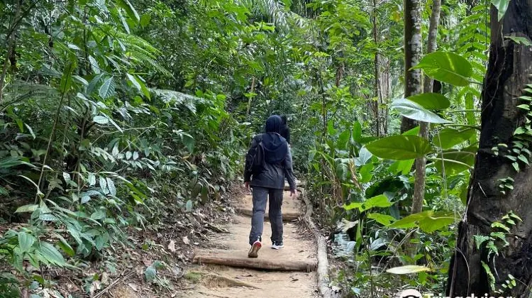
Bukit Kutu
Bukit Kutu, or Kutu Hill, is a moderate and historical trail that passes by some of the ruins of a colonial hill station. It is located in Kuala Kubu Bahru, about 70 km from Kuala Lumpur. It is suitable for intermediate hikers or those who want a longer and more historical hike.
- Difficulty level: Moderate
- Distance: 10.5 km
- Duration: 4-6 hours
- Elevation gain: 1050 m
- Terrain: Dirt path with rocks and roots; some steep sections; some ruins and relics
- Scenery: Rainforest view and waterfall view
- Attractions: The Kutu Waterfall, The Kutu Summit, etc.
- Accessibility: Easy to access from the parking area near the trailhead
- Safety: Somewhat marked and maintained; some sections are steep and slippery; need to register at the checkpoint and pay a fee of RM5 per person
- Tips: Bring enough water and snacks as there are no shops or facilities along the way; wear sturdy shoes and gloves as there are some ropes to assist you in climbing; explore the ruins and relics of the former hill station
Go Hiking in Kuala Lumpur Today!
Hiking Kuala Lumpur is a wonderful activity for anyone who loves nature and hiking. It offers a variety of trails for different levels of difficulty and duration, as well as a range of attractions and facilities for different interests and preferences. Whether you want to enjoy the panoramic views, the cool climate, the cultural heritage, or the wildlife diversity, hiking Kuala Lumpur has something for everyone.
If you are interested in trying hiking Kuala Lumpur, you can book your tickets online or at the nearest station or stop to the hiking trail. You can also visit trip.com website to find more travel tips, deals, and packages for your Kuala Lumpur trip. Don't miss this opportunity to experience one of the best hiking destinations in Malaysia.
Hiking Kuala Lumpur
-
What are some popular hiking trails in Kuala Lumpur?
-
What is the difficulty level of Bukit Broga trail?
-
What is the distance and duration of Bukit Broga trail?
-
What attractions can be found along Bukit Broga trail?
-
How accessible is Bukit Broga trail?
-
What safety precautions should I take on Bukit Broga trail?
-
What is the difficulty level of FRIM Forest Skywalk trail?
-
What is the distance and duration of FRIM Forest Skywalk trail?
-
What attractions can be found along FRIM Forest Skywalk trail?
-
How accessible is FRIM Forest Skywalk trail?
-
What safety precautions should I take on FRIM Forest Skywalk trail?
-
What is the difficulty level of Gunung Nuang trail?
-
What is the distance and duration of Gunung Nuang trail?
-
What attractions can be found along Gunung Nuang trail?
-
How accessible is Gunung Nuang trail?
-
What safety precautions should I take on Gunung Nuang trail?
-
What is the difficulty level of Taman Tugu trail?
-
What is the distance and duration of Taman Tugu trail?
-
What attractions can be found along Taman Tugu trail?
-
How accessible is Taman Tugu trail?
-
What safety precautions should I take on Taman Tugu trail?
-
What is the difficulty level of Bukit Kutu trail?
-
What is the distance and duration of Bukit Kutu trail?
-
What attractions can be found along Bukit Kutu trail?
-
How accessible is Bukit Kutu trail?
-
What safety precautions should I take on Bukit Kutu trail?
-
Where can I book tickets for hiking in Kuala Lumpur?